Hello and welcome to this live blog. Here we keep you informed of the thunderstorm and tropical temperatures in the Netherlands and in the rest of Europe.
In the coming days, considerably cooler throughout the Netherlands, but the weather is still going to be. This will be between 21 and 25 degrees tomorrow, while sun and stacking clouds alternate. On Friday the temperatures are between 21 and 27 degrees, and there is a bright sun. During the weekend it remains sunny and around 25 degrees, but a shower is more often possible.
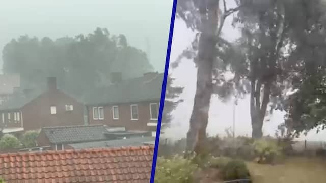
Winterswijk heavily hit by thunderstorms: 127 reports of storm damage In the past hours, the emergency services and the municipality of Winterswijk 127 have received 127 reports of storm damage after “short -term rain showers and gusts were in the Gelderland site”. Among the reports were fallen trees, broken branches and blocked roads. A business premises also collapsed, the safety region reported earlier.
First of all, the main roads are released, the municipality has decided in consultation with the fire brigade and local contractors. “As a result, the accessibility of Winterswijk has largely been restored, and emergency services and vital locations such as the SKB hospital and fire station are easily accessible.”
Residents are “urgently” asked to go on the road only if it is really necessary. “The clean -up work is still in full swing. There can still be trees and branches on the roads,” said the safety region. “Take dangerous situations into account, especially when it gets dark. The visibility then becomes more limited, while obstacles may not have been removed.”
0:49
Lots of hail, wind and rain during stormy weather in parts of the Netherlands
A fallen tree ended up on a car in Winterswijk.
A lot of precipitation has fallen in the Achterhoek and Twente: about 20-40 millimeters. Weerplaza warns that the southeast of Drenthe will also suffer from heavy rain showers.
In the east of the country, several loose showers fall tonight that can turn out very brightly locally. Then the precipitation leaves for Germany. There are already hefty showers there.
Roads around Winterswijk Close through over -blown trees around Winterswijk, located in the province of Gelderland, several roads are closed by fallen trees. It concerns the N318 and N319.
In Gelderland, Code Oranje was previously applied due to heavy showers and gusts of wind. At an amateur weather station in Winterswijk, a gust of wind of 113 kilometers per hour was measured. Earlier, the roof of a business premises collapsed by heavy showers in the Gelderse town.
Also no longer code orange for thunderstorms code orange is over throughout the country. In the provinces of Limburg, Gelderland, Drenthe and Overijssel, only Code Geel now applies. Code Geel is also in force in Noord-Brabant and Groningen. The KNMI warns of thunderstorms, small hailstones, gusts of wind and lots of rain in a short time.
No more Code Oranje Due to heat the Code Oranje Due to extreme heat, has now been terminated throughout the country. The mercury has fallen everywhere to below 30 degrees. There is still orange code for heavy thunderstorms in a few provinces. This is the current state of affairs:
Thirteen weather stations note a heat wave on thirteen weather stations is today listed a heat wave. These are the Limburg weather stations Arcen, Ell and Maastricht, the Brabant stations Woensdrecht, Gilze-Rijen, Eindhoven and Volkel, the Zeeland Westdorpe, the Gelderland Herwijnen and Deelen, De Bilt, Rotterdam and Schiphol.
Yesterday there was already a regional heat wave in Eindhoven, after the temperature for the third day in a row rose to 30 degrees or more. The Brabant city was the only place where the Kwik already indicated 30 degrees or more on Sunday.
Because in De Bilt today, 30 degrees or more was measured for the third day in a row, there is also a national heat wave. It is the first time since 2022 that that happens.
Rainwater gushes through the roof of business premises in Winterswijk
The roof of the Winterswijk business premises is collapsing in the roof of a business premises on the Rondweg Zuid in Winterswijk, partly collapsed. There was no one in the building anymore and so there were no injuries. According to the North and East Gelderland Security Region, the building was probably struck by a heavy shower that exceeded. Many trees have been blown over in Winterswijk.
According to Weeronline, there may have been a fall wind. It arises because a large amount of cold air deposits down through a sturdy mood. Warm air rises, after which it cools again when it gets higher. The ‘heavy’ air falls down, as it were, and that is accelerated if there is very heavy rainfall.
The temperature is all over its peak all over the Netherlands for today. On the card above you can see which maximum temperatures have been measured. The highest temperature was measured in Maastricht, where it became 39 degrees. On Vlieland they kept their heads the coolest with ‘only’ 22 degrees.
Large differences in temperatures Now , partly due to the showers, the temperatures now vary widely in the Netherlands. In the west of the country, the temperatures decrease towards 20 degrees, while in the east and south of the country it is still more than 30 degrees.
In this article we explain how those big differences come about.
The western coast and the border areas with Germany are currently taking up considerable showers. Especially in the east that is accompanied by thunder and hail.
Also Code Oranje in Drenthe and Groningen In addition to Limburg, Noord-Brabant, Gelderland and Overijssel, there is now also Code Oranje in Drenthe and Groningen. Sturdy thunderstorms also occur in the northern provinces.
Heavy thunderstorms in the east, a little less intense in the west in Dutch areas that borders to Germany now thunder well. The showers can be very bright, with thunder, hail and heavy gusts of wind from 75 to 100 kilometers per hour.
Showers also pull over the coastal areas in the west. They are large -scale, but less intense.
At four highest temperature ever in the Netherlands: 39 degrees in Maastricht in Maastricht, today a temperature of 39 degrees was officially measured, Weerplaza reports. That is the fourth highest temperature ever measured in the Netherlands. The highest temperature ever in our country is in the name of the Gilze-Rijen weather station: 40.7 degrees on July 25, 2019.
Meteorologist Jaco van Wezel says that 39 degrees were measured at the airport near Maastricht. He calls it “very real” that some people measure 40 degrees in their backyard. In the meantime, the temperature is over its peak in Maastricht and it cools down again.
Heat causes problems on the track throughout the country, there are malfunctions on the track, where the heat influences. There is, among other things, a change of exchange between Amsterdam and Schiphol. There is a signal failure between Breda and Roosendaal and there are defective trains on various routes.
According to a spokesperson for rail manager ProRail, an “increased fault image” can be seen. That was also the case yesterday, when it was also very hot. “But it’s manageable.”
Due to the high temperatures, rails can turn off and electronics can become disrupted, resulting in signal and changing disruptions.
First thunderstorms, the Netherlands will reach a sturdy mood on Zeeland, reports the KNMI. The yellow color on the card means that hailstones are accompanied by between 0 and 2 centimeters. There are also showers over the Wadden Islands, which occasionally yield some thunderstorms.
The showers that crossed Limburg (the colorful collection of colors at the bottom right) are now driven Germany.
Code Oranje went into Limburg, Gelderland and Overijssel In the three southeastern provinces, Code Oranje is now due to thunderstorms with very heavy gusts of wind and large hailstones. Code Oranje also applies because of the heat.
Temperature fell sharply on the coast The temperature on the Dutch west coast has fallen considerably in recent hours. In The Hague the temperature dropped to around 22 degrees and the power of the wind has increased somewhat.
RWS: ‘Take thunderstorms into account during your trip’ Rijkswaterstaat calls on road users to take thunderstorms into account during their journey. “This afternoon the clouds will increase and during the evening rush hour, thunderstorms with gusts of wind and hail can occur locally,” says RWS. “Keep this in mind during your trip. Go well prepared on the road and check the current weather and traffic info.”
Power failure in part of Enschede Hundreds of homes in Enschede are without electricity due to a malfunction, Oost reports. 1,147 households in the east of the city have been hit.
The current went out around 12.45 pm. Enexis expects the malfunction to be resolved at 2.45 pm.
Officially Warmest July 2 ever measured for the second day in a row is a date-warming record, Weeronline reports. In De Bilt, the temperature has risen to 33.7 degrees at 1.30 pm. This makes it officially the hottest July 2 ever since the measurements started in 1901. The previous record was 33.6 degrees and was measured in 2010.
Nationally it is even warmer. Until now it is the warmest in Maastricht with 37.4 degrees.
Code yellow due to thunderstorms in Overijssel, Gelderland and Limburg also applies this afternoon code orange due to thunderstorms. That does not mean that it stays calm in the rest of the country. In the provinces of Noord-Brabant, Utrecht, Flevoland, Drenthe, Friesland and Groningen, code yellow applies this afternoon due to thunderstorms.
Code Geel is in force in Noord-Brabant, Utrecht and Flevoland between 3 p.m. and 6 p.m. In the north of the country the weather warning applies from 5 pm to 8 pm.
Earlier today, the European Monitoring Service Estofex had already placed the far east of the Netherlands and parts of Germany already under code 3 because of approaching thunderstorms. Code 3 is the heaviest warning of the storm service. It means that very serious weather conditions are coming.
For the Netherlands, a warning has been issued for parts of Gelderland, Overijssel, Drenthe and Groningen. Estofex is mainly concerned about heavy gusts of wind. According to the KNMI, they can have a force of 75 to 100 kilometers per hour. In Germany there is a chance of tough weather in the federal states of North Rhine-Westphalia, Lower Saxony and Bremen.
Tomorrow immediately end to heat wave The heat wave will come to an end tomorrow, because then in De Bilt it will be ‘only’ 23 degrees. With a duration of five days we can therefore speak of a narrow heat wave, with an exceptionally hot day on Tuesday 1 July, says Weeronline.
The longest heat wave in De Bilt lasted eighteen days and was measured from July 29 to August 15, 1975.
For a heat wave, a series of at least five summer days (25 degrees or more) is required, with tropical hot at least three of those days (30 degrees or more). For an official heat wave, those temperatures must be measured in De Bilt.
De Bilt is the indicator for the weather in the Netherlands, because the measurements there are seen as representative for the whole of the Netherlands because of its location.
First official heat wave in three years at 11.20 am it became 30.2 degrees in De Bilt: this now officially has a heat wave. The KNMI and WeerOnline report this. It is the first official heat wave since August 2022. Then the heat wave lasted eight days: from August 9 to August 16.
What can you expect and what can you do with heavy thunderstorms? The KNMI lists the most important points for you.
Killing through forest fires in Spain in Spain were killed in a forest fire. This was probably caused by the high temperatures and the drought. In many places in Spain, the temperature has been fluctuating around 40 degrees for days.
The authorities in the Northern Spanish region of Catalonia have instructed around 20,000 people to stay inside by two forest fires that broke out simultaneously. The fire brigade says that the weather conditions played a role in the rapid distribution of the fire.
Prime Minister Pedro Sánchez has expressed his condolences to the relatives of the two people who died in the fires on X.
Code Oranje in Overijssel, Gelderland and Limburg for heavy thunderstorms The KNMI releases Code Oranje for the provinces of Overijssel, Gelderland and Limburg due to heavy thunderstorms. The warning applies from 3 p.m. to 7 p.m. for Limburg and from 4 p.m. to 8 p.m. for Overijssel and Gelderland. A lot of precipitation can fall in the border regions in particular. Hail stones the size of three centimeters can fall there.
From all over the country, more than fifty reports were received in the Dierenbescherming about young swallows that have been in trouble due to overheating. According to the control room, this has not happened on this scale before.
Animal protection calls on people to be alert to young birds in need during the warm weather and to call for advice. The organization also calls for a weakened swallow not to throw in the air. “Then they fall down just as fast.”
Two heat-related deaths in France in France, the extreme has again demanded two victims. Minister of Climate Transition Agnès Pannier-Runacher has just announced this. It is unknown where and how the two died.
Also in Belgium warnings for heat and thunderstorms in Belgium today applies local code orange because of the expected heat. The weather alarm is in force in the provinces of Limburg, Liège and Luxembourg.
In the afternoon, just like in the Netherlands, there is a chance of heavy thunderstorms at the Zuiderburen. A lot of rainfall can fall in a short time, the RMI reports. The warning for thunderstorm is code yellow. It will apply this afternoon in more areas.
Cycle path comes up through the heat: cyclist seriously injured after falling
A cyclist was seriously injured yesterday during a ride through Noord-Brabant. A cycle path had stood up through the heat. He overlooked that, after which he was launched and made an ugly taste. The man was rushed to the hospital.
Turkey receives a grip on forest fires in the Turkish provinces of Izmir and Manisa, the fire brigade is getting more and more grip on the forest fires that have been raging for a few days. That is what Minister of Agriculture and Forest Management Ibrahim Yumakli says. A number of hot spots are now partly under control. The minister reports locally, the minister reports.
A number of forest fires also rage in Hatay. Due to the high temperature and strong wind, the fight against the fire there is less well. According to Yumakli, extinguishing aircraft and twelve helicopters are carried out.
The last night was tropical in the southwest, Weerplaza reports. That means that the temperature did not fall below 20 degrees. Incidentally, it didn’t matter much, because at the weather station of Hoek van Holland a temperature of exactly 20 degrees was measured at the ‘coldest’ moment. The last tropical night was in August last year.
Northwest has to do with showers Currently, there is a local shower in the northwest of our country. At the bottom of the head of Noord-Holland, Texel, Vlieland and the west of Friesland it rains or rained. The showers head towards the northeast, so that Terschelling and Ameland still have to deal with it.
Germany is bracing for hottest day of the year in Germany, the temperature today may rise to local 40 degrees. Especially the States Brandenburg and North Rhine-Westphalia have to deal with it. Our eastern neighbors take into account the hottest day of the year. In the Netherlands, the hottest day of the year so far was yesterday.
High temperature and high humidity expects, it will be tropically warm again today, Weerplaza reports. Locally the temperature can rise to 37 degrees. Especially in the interior it gets very hot. The humidity is high, which means that the damp will feel.
On the coast it is slightly less hot with 25 to 30 degrees. Moreover, during the day a cooling western wind lights up. That also causes a little more clouds.
Thunderstorms can occur during the afternoon. Especially in the east the chance of a blow is present. The thunderstorms will be accompanied by hail and gusts of wind.
More French departments to code orange also in France is holding the heat. Today the temperature can rise to local 39 degrees. The night from Tuesday to Wednesday was very hot. In Paris it was no cooler than 29.5 degrees, reports BFMTV .
Yet in less departments code red applies. In five departments, scaled to code orange, including in Ile-de-France. Only in the Departments Aube, Yonne, Loiret and Cher is code red still in force.
Hello and Welcome to this Live blog. Here we will keep you informed of the thunderstorms and tropical temperatures in the Netherlands and the rest of Europe.
The Coming Days Will Be Consider -Ox Cooler Throughhout The Netherlands, But The Weather Will Still Be Nice. For Example, Tomorrow It Will Be Between 21 and 25 Degrees, While Sun and Cumulus Clouds Alternate. On Friday the temperatures will be between 21 and 27 degrees, and there will be a bright sun. The Weekend Willain Sunny and Around 25 Degrees, But a Shower is more Likely.
Winterswijk Hit Hard by Thunderstorms: 127 Reports of Storm Damage In The Past Few Hours, The Emergency Services and the Municipality of Winterswijk Have Received 127 Reports of Storm Damage After “Letter Heavy Rainfall and Gusts of Wind” in the Gelderland Town. The Reports Included Fallen Trees, Broken Branches and Blocked Roads. A Commercial Building also Collapsed, The Safety Region Reported Earlier.
First of All, The Main Roads Will Be Cleared, The Municipality Has Decided in Consultation with the Fire Brigade and Local Contractors. “As a result, the accessibility of Winterswijk Has Largely Been Restored, and Emergency Services and Vital Locations Such as the SKB Hospital and Fire Stations Are Easily Accessible.”
Residents are “Urgently” Asked to Only Go On The Road If It is Really Necessary. “The Clean-Up Work is Still in Full Swing. There May Still Be Trees and Branches On The Roads,” Accordination to the Safety Region. “Take into account dangerous situations, eSpecially when it gets dark. Visibility will then be more limited, while obstacles may not yet have leg removed.”
 0:49
0:49
Lots of Hail, Wind and Rain Duration Severe Weather in Parts of the Netherlands
An Overturned Tree Has Landed on a Car in Winterswijk.
A lot of precipitation has fallen in the Achterhoek and Twente in a short time: about 20-40 millimeters. Weerplaza Warns That the Southeast of Drenthe Will also Suffer from Heavy Rain Showers.
Tonight There will be Several Isolated Showers in the East of the Country That Can Be Very Fierce Locally. After that, The Precipitation Will Move Towards Germany. There are already heavy showers there.
Roads Around Winterswijk Closed Due to Fallen Trees Around Winterswijk, locationed in the Province of Gelderland, Several Roads Have Been Closed Due to Fallen Trees. This groups The N318 and N319.
Orange code was Previously in effect in Gelderland due to heavy showers and gusts of wind. A gust of wind or 113 kilometers per hour was a measured at an amateur weather station in Winterswijk. Earlier, The Roof of a Commercial Building in The Gelderland Town also Collapsed Due to Heavy Showers.
No More Code Orange for Thunderstorms Either Code Orange has passed through the country. Code Yellow Now only Applies in The Provinces of Limburg, Gelderland, Drenthe and Overijssel. Code Yellow is also still in effect in Noord-Brabant and Groningen. The KNMI Warns of Thunderstorms, Small Hailstones, Gusts of Wind and a Lot of Rain in a Short Time.
No More Code Orange Due to Heat The Code Orange Due to Extreme Heat Has Now ended Throughhout the Country. The Mercury Has Fallen Below 30 Degrees Everywhere. Orange Still Applies to Severe Thunderstorms in Some Provinces. This is the Current State of Affairs:
Thirteen Weather Stations Record A Heat Wave a Heat Wave Has Been recorded at Thirteen Weather Stations Today. These are the Limburg Weather Stations Arcen, Ell and Maastricht, The Brabant Stations Woensdrecht, Gilze-Rijen, Eindhoven and Volkel, The Zeeland Westdorpe, The Gelderland Herwijnen and Deelen, De Bilt, Rotterdam and Schiphol.
Yesterday There was Already a Regional Heat Wave in Eindhoven, after the temperature Rose to 30 Degrees or More for the Third Day in a Row. The Brabant City was the only place where the mercury already indicated 30 degrees or more on Sunday.
Because 30 Degrees or More was also Measured in the Bilt for the Third Day in a Row Today, there is also a National Heat Wave. It is the first time since 2022 that this has happened.
Rainwater Gushes Through the Roof of a Commercial Building in Winterswijk
Roof of Business Premises in Winterswijk Collapses The Roof of A Business Premises on the Rondweg Zuid in Winterswijk Has Partarily Collapsed. There was no one in the building and there were no injuries. Accordance to the North and East Gelderland Safety Region, The Building was a probably hit by a heavy shower that passed over. Many Trees Have Fallen in Winterswijk.
Accordance to Weeronline, there may have leg a downburst. This is created because a large amount of cold air plungs down through a heavy shower. Warm air rises, after which it cools down again as it rises highher. The ‘Heavy’ Air, As It Were, Falls Down, And This Is Accelerated If There Is Very Heavy Rainfall.
The Temperature is Peak for Today Everywhere in the Netherlands. The Map above shows the maximum temperatures that have leg measured. The Highest Temperature was Measured in Maastricht, Where It was 39 Degrees. In Vlieland they Kept Their Heads Coolest with ‘Only’ 22 Degrees.
Major Differences in Temperatures Now partly Due to the Showers, Temperatures Now Vary Greatly in the Netherlands. In the West of the Country, Temperatures Are Falling Towards 20 Degrees, While in the East and South of the Country It is Still Well about 30 Degrees.
In this article we explain how these major differentials arise.
The Western Coast and the Border Areas with Germany Are Currently Experiencing Heavy Showers. This is accompanied by thunderstorms and hail, eSpeciate in the East.
Orange also in Drenthe and Groningen in Addition to Limburg, Noord-Brabant, Gelderland and Overijssel, code Orange Now also Applies in Drenthe and Groningen. Heavy Thunderstorms also Occur in the Northern Provinces.
Severe Thunderstorms in The East, Slightly Less Intense in the West there are heavy Thunderstorms in the Dutch Are you Border Germany. The Showers Can Be Very Fierce, With Thunderstorms, Hail and Severe Gusts of Wind or 75 to 100 kilometers per hour.
Showers are also passing over the coastal areas in the west. These are Larger in Scale, But Less Intense.
Fourth Highest Temperature ever in the Netherlands: 39 Degrees in Maastricht A Temperature of 39 Degrees Has Official Been Measured in Maastricht Today, Reports Weerplaza. That is the Fourth Highest Temperature Ever Measured in the Netherlands. The Highest Temperature ever in our country is in the name of Weather Station Gilze-Rijen: 40.7 Degrees on July 25, 2019.
Meteorologist Jaco van Wezel Says That 39 Degrees Has Been Measured at the Airport Near Maastricht. He calls it “very realistic” that some people measure 40 degrees in their backyard. The temperature in Maastricht has now passed its peak and is cooling down again.
Heat Causes Problems on the Railways There Are Malfunctions on the Railways Throughhout the Country, With The Heat Having An Impact. There is, Among Other Things, A Point Failure Between Amsterdam and Schiphol. There is a signal failure between Breda and Roosendaal and Defective Trains on Various routes.
Accordance to a spokesperson for railway manager ProRail, there is an “Increased failure pattern”. That was also the case yesterday, when it was also very hot. “But it is manageabla.”
Due to the high temperatures, Railway tracks can expand and electronics can Become Disrupted, resulting in Signal and Point Failures.
First Thunderstorms Reach The Netherlands A Heavy Shower is Heading for Zeeland, Reports The KNMI. The Yellow Color on the Map Means That hailstones between 0 and 2 centimeters are associated with it. Showers are also passing over The Wadden Islands, which occasionally caus some thunderstorms.
The Showers That passed about Limburg (The Colorful Collection of Colors at the Bottom Right) Have Now Driven Into Germany.
Orange code in effect in Limburg, Gelderland and Overijssel Code Orange is now in effect in The Three SouthEastern Provinces Due to Thunderstorms with Very Heavy Gusts of Wind and Large Hailstones. Orange also Still Applies There Due to the Heat.
Temperature has dropped considerably on the coast the temperature on the Dutch west coast has dropped considerably in recent hours. In The Hague the Temperature has dropped to around 22 Degrees and the Force of the Wind Has Increased Somewhat.
RWS: ‘Take Into Account Thunderstorms Duration Your Journey’ Rijkswaterstaat Calls on Road Users On X to Take Thunderstorms Into Account Duration Their Journey. “Cloud cover will increase this afternoon and local thunderstorms with gusts of wind and hail may occur duration the event rush hour,” Says RWS. “Take this into account duration your journey. Prepare Well Before you set off and check the current weather and traffic information.”
Power Outage in Part of Enschede Hundreds of Homes in Enschede Are Without Power Due to a Malfunction, Reports East . 1,147 Households in the East of the City have leg affected as a result.
The Power Went Out Around 12:45 pm. Enexis expects the malfunction to be resolved again at 2:45 pm.
Official Warmest July 2 Ever Measured for the Second Day in a Row There is a Date Heat Record, Reports Weeronline. In De Bilt the Temperature Rose to 33.7 Degrees at 1:30 pm. This official makes it the Warmest July 2 ever, since Measurements Begen Begen in 1901. The Previous Record was 33.6 Degrees and Was Measured in 2010.
Nationally it is just as warmer. So far it is Warmest in Maastricht with 37.4 Degrees.
Code Yellow also Due to Thunderstorms Code Orange Applies This Afternoon in Overijssel, Gelderland and Limburg Due to Thunderstorms. That Doesn’t Mean That Things Will Remain Calm in the Rest of the Country. Code Yellow Applies This Afternoon in The Provinces of Noord-Brabant, Utrecht, Flevoland, Drenthe, Friesland and Groningen due to Thunderstorms.
Code Yellow is in effect in Noord-Brabant, Utrecht and Flevoland Between 3:00 pm and 6:00 pm. In The North of the Country, The Weather Warning Applies from 5:00 pm to 8:00 pm.
Earlier Today, the European Monitoring Service Estofex had Already Placed the far East of the Netherlands and Parts of Germany Under Code 3 Due to approaching Thunderstorms. Code 3 is The Most Severe Warning from the Storm Service. It mean that very serious weather conditions are approaching.
A Warning Has Been Issued for Parts of Gelderland, Overijssel, Drenthe and Groningen in The Netherlands. Eststofex is a particularly concerned about Severe Gusts of Wind. Accordance to the KNMI, these can have a force or 75 to 100 kilometers per hour. There is a Chance of Severe Weather in the German States of North Rhine-Westphalia, Lower Saxony and Bremen.
Heat Wave Will End Immediately Tomorrow The Heat Wave Will End Tomorrow, because it will be ‘Only’ 23 Degrees in De Bilt. With a Duration of Five Days, We Can Therefore Speak of A Narrow Heat Wave, With An Exceptionally Warm Day on Tuesday, July 1, Says WeerOnline.
The Longest Heat Wave in De Bilt Loaded Eighteen Days and Was Measured From July 29 to August 15, 1975.
For a heat wave, a series of at Least Five Summer Days (25 Degrees or More) is required, with it Becoming Tropical Warm (30 Degrees or More) on At Least Those of Those Days. For an official heat wave, those temperatures must be measured in De Bilt.
De Bilt is The Yardstick for the Weather in the Netherlands, because the Measurements there are as representative for the whole of the Netherlands Due to Their Location.
First Official Heat Wave in Three Years at 11:20 AM IT Was 30.2 Degrees